$8.50 Shipping on all USA orders

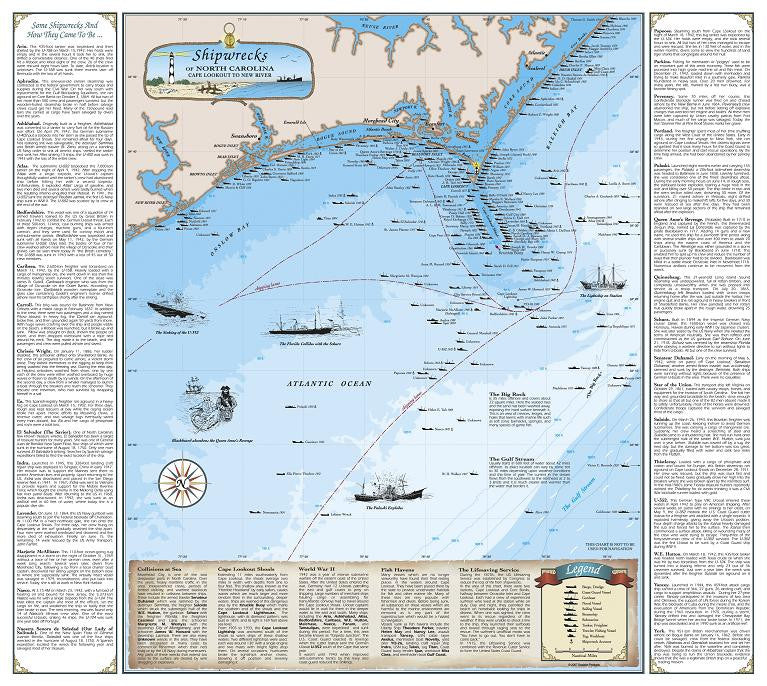
North Carolina Shipwreck Chart: Cape Lookout to New River

$ 17.95
Format

This chart contains over 200 shipwrecks along the North Carolina coastline.  It measures 18.75" x 20", is in full color, and is printed on quality 80 lb enamel paper - Perfect for framing!  Not only will you see where these famous wrecks are located, but also included on the chart is a collection of 31 stories about how many of these shipwrecks came to be.  Read below about the Queen Anne's Revenge, just one of themany fascinating ships mentioned on the chart...

Queen Anne's Revenge - "Built in 1710 in England and captured by the French, this three-masted 26 gun ship, named La Concorde, was captured by the pirate Blackbeard in 1717.  Adding 14 guns and a new name, he used this ship for  a six-month time period along with several smaller ships and over 400 men to attack 20 shipsalong the eastern coast of America and the Caribbean.  The Revenge was either grounded in a storm or purposely sunk by Blackbeard in in June 1718.  This enabledhim to split up his crew and and reduce the number of ways that their plunder had to be divided.  Blackbeard was killed in a battle outside Ocracoke Inlet in November, 1718.  Numerous artifiacts continue to be recovered from the wreck."

 Full color. 18.75" X 20"

Guarantee

100% satisfaction guaranteed. If you do not like your product for any reason, return it within 14 days for a refund. Buyer pays for all shipping costs.

Shipping and Handling

Paper and laminated shipwrecks charts and other nautical prints are shipped rolled. Fishing charts are shipped flat.

All frames and framed prints are shipped boxed and will ship seperately from non-framed prints.